Updated 13 Feb 2010

WIRKSWORTH Parish Records 1600-1900

Return to Front Page

MENU

Last

Photo 384

Next

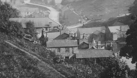
Chapel Hill climbs steeply past 6 stone terrace houses (26-24-22-20-18-16).

Taken Dec 1941. From Chapel Hill looking down Water Lane.

Dates:
Photo taken:
Size:Postcard
Source:

Click on photo for enlargement (on CD only)
Have any more information about this photo? 
Please e-mail the author on:

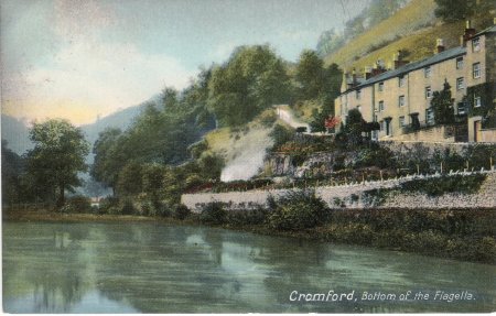
Cromford, bottom of the Fiagella

A road called Via Gellia enters Cromford at Water Lane by Cromford Pond, which is in this photo (but see letter below). It is thought the photographer wrote the name down wrongly when he quizzed a local as to where he was. The Pond was built by Sir Richard Arkwright to help power his Cotton Mill, and Via Gellia was named after the Gell family who built it to supply a mine. It is also thought that the woollen material called Viyella was named after Via Gellia.

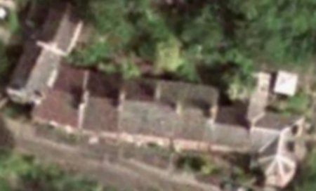
..the imposing stone terrace at the top [of Chapel Hill] is clearly much older. Number 16, Via Gellia House with its large bays, was built by Nathaniel Wheatcroft about 1780 and originally included Number 18. The Wheatcroft family operated boats on the canal wharf and in 1830 advertised fast passenger boats; the house was occupied by the family until well into the nineteenth century, and the name can still be seen on the wharf. Number 22 with its fine porch was built about 1780 although interior evidence of roof lines and windows suggests it may incorporate an older building. Number 26 still has original cast iron window frames in the upper storey, with small inner lights. At the rear, the houses have doors in the first storey which may well have been used for unloading outwork from the mills.....
"The Cromford Guide" by Bayles & Ede, page 41

The stone terrace on Chapel Hill, built about 1780.

------------------------------

From:Steve Barry & Stephanie Haywood (haywoodbarry#btopenworld.com)
Subject: Re: Fiagella, Cromford?
Date: Sun, 25 Sep 2005 09:38:46 +0100

Hello John

I see other people have beaten me to telling you it is probably Via Gellia, but I thought I would add that my parents - from long back Derbyshire folk - always pronounced it Vyajelly and it was a while before I linked the place with the Roman spelling! As a child I thought it sounded rather tasty.

Kind regards

Stephanie

------------------------------

From:Margaret Howard (margaret.howard4#btinternet.com)
Subject: Re Photo 384, Correct name "Via Gellia" not "Fiagella"
Date: Mon, 26 Sep 2005 20:22:28 +0100

Hello John,

Just seen your appeal on the website re the above and as I've been researching various bits of history of the area around Bonsall, especially the lead mines and soughs, for inclusion in the proposed new Bonsall History Society book, due out about Christmas. I thought that I'd drop you a line.

This picture is an unusual shot and is not of what everyone knows as Cromford Pond, this is a view of the mill pond situated upstream of the small mill on the left hand side of of the Water Lane/Via Gellia junction as one travels towards Bonsall from Cromford. I believe that the Arkwright Society now have this small mill as a visitor centre. The correct Cromford pond is downstream from where Nellie Kirkham always told me was Richard Arkwright's original workshop, the building with the overshot waterwheel still intact (that now sells baskets), on the righthand side of Water Lane traveling towards Grangemill and Newhaven from Cromford. Cromford pond which is at the back of the Greyhound Public House between Water Lane and Scarthin (where Scarthin Books are found) was used to store water by Arkwright from two sources.
(a) Bonsall Brook which flowed down from Bonsall and joined the stream flowing along the Via Gellia, which has it's source at Shothouse springs, in Winster Parish, but on the Grange Mill/ Winster road, just north of the Holly Bush Inn at Grange Mill cross roads. Incidently the water from this brook was also stored in a mill pond to work Grange Mill, which originally was owned by the monks. This mill pond was restored a few years ago by the present owner of Grange Mill, and is now a popular fishing spot.
(b) The water that came out of Cromford sough that is found at the back of the Butcher's shop at the bottom of Cromford Hill. He used a series of lock gates and used the water for a set time of hours during twenty four hours to either go to the pond where it could be stored, or under what is now the A6 and over the metal viaduct (recently destroyed by a lorry and not yet replaced) to his mill to use the water power to work his water frames.

There was no proper through road as such until the Cromford/Grange Mill/Newhaven Turnpike was constructed in 1804, apart from Gell's road from his lead mines in his private liberty at Griffe Grange (otherwise known as Bret-Griffe) down to Cromford. Somewhere amongst all my records I've got the date of closure of the road as a turnpike, but it's not handy. This turnpike met the Nottingham/ Newhaven turnpike (1759) near Pikehall, this latter turnpike came from Nottingham via Alfreton, Matlock (down Steep Turnpike), Matlock Bridge, Snitterton Road (the hill out of Matlock being known then as "Smithy Hill" because of the blacksmith's forge situated on it), Snitterton ale house (where extra horses were attached depending upon the amount of wheels and weight of the carriage to pull the carriage over Oker Hill), Wensley Hill, Winster (extra horses attached to pull up West Bank to the Miner's Standard), Elton Common, Pikehall and finally Newhaven to catch connecting coaches. After the present road (now the A6) was blasted through Scarthin, Cromford in 1815 which thus opened up the road through Matlock Bath to Matlock (it was a cul de sac until then), routes then became more accessible and less traffic used the Nottingham/Newhaven turnpike. Then came the railway which took apart from local, most of the traffic. Some references for this information are:- Peakland Roads and Trackways by A. E. Dodd and E. M. Dodd (2000), Lead and Lead Mining in Derbyshire by Arthur H. Stokes, F.G.S. and Lead Miner's Heyday by Ron Slack (2000).

I'm quoting from the Bonsall Map "Business in Bonsall" section for the origin of the name Viyella. "In 1867 Thomas Else of Matlock built a cotton mill on the site of a cornmill formerly owned by the Gell family, the Via Gellia Mill was taken over by Wm. Hollins & Co in 1890 and it was there they developed 'Viyella' yarn (a corruption of Via Gellia)". Incidently I don't know if you've seen the Bonsall Map but I contributed the geology and leadmining section.

I don't know if you know (looking at the photo) but as soon as one enters the Via Gellia from Water Lane, one is in Bonsall parish. Just off to the right of the photo is a small building which I think was the toll house of the turnpike, it is clearly shewn on the Tithe map (1848) and Schedule (1846) to be in Bonsall. Bonsall brook forms the parish boundary, so Middleton parish is to the left of the mill pond, Cromford parish behind the photographer and looking straight ahead is all Bonsall parish. The main road is seen just above the mill pond and Chapel Lane the steeply rising track above the Via Gellia on which the row of cottages is built used to be the only road into Bonsall from Cromford (entering Bonsall at Town End and the church) until another road was blasted up from Bonsall Hollow by lead miners who were paid in ale for their services in 1736. That road is now known as the Clatterway, but on the Census returns of the 1800's it is called the Latterway, which to my mind makes better sense, as it was a second or latter way into Bonsall. A descendent of the Ferne family a Mrs.Turnor was one of the people who contributed to the cost.

Hope this information helps, and that I've not bored you with it. I didn't send it to DerbysGen site as I thought it perhaps too long.

Margaret Howard,
Bonsall.

Compiled, formatted, hyperlinked, encoded, and copyright © 2005, All Rights Reserved.