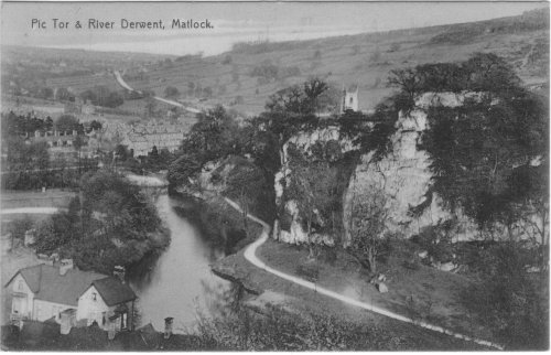
Mike Spencer explored the area, and reported as follows:
The picture was taken behind Harvey Dale on Dale Road. For any budding David
Baileys if coming into Matlock from Derby just before the bridge over the
Derwent take the left turn to Snitterton.You need to abandon your car
somewhere near here by the way because just after the French Wine premises
you then turn left up to Bridge Farm and into the fields beyond, take the
left fork,where the sign has fallen down and follow the path through the
stile and across the field through the wide opening in the hedge. About ten
yards into that field you will find some sticks about ten foot to your left
,an X marks the spot .If you do not think it is exactly from there you could
try your luck a bit further down but make sure you have a big plank because
you will be standing in mid air over the Quarry! Which is the most likely
spot from where it was taken before more of the cliff face was
destroyed. There was once a footpath along here but has been closed for some
time, it is now closed of with barbed wire, more than one person dying from a
fall from the Quarry top.The house in the front left is currently still
standing on Dale Road, an accountants premises. The chimneys and roofs before
it belong to houses on Holt Lane. The river, now in flood, looks like it does
in the picture, but the sandy point on the right bank now extends into the
middle of the river for most of the year. The river at this point is about to
go under the Matlock to Derby railway bridge. The white track extreme left is
a Cycling track and beyond that, three tennis courts. On the 1880 OS this was
once a rifle range with the target on the other side of the river! The Tennis
courts were provided for his friends by Charles EVANS jeweller along with
a "secret garden", the courts were operative until the second world
war, there was also a bowls green which lasted into the 1980s. The path on
the right is Lovers Walk. The white rock just after the bend in Lovers Walk
is Pic Tor called Pig Tor on the 1898 OS, there were no paths along there in
1898, well I wouldn't fancy being shot at either. One of the many rubbish
dumps can be found near Pic Tor, now fenced off. The church is St Giles
parish church of Matlock. The tall buildings in the middle are houses on
Knowleston Place, named after the KNOWLES family, one of the oldest houses in
Matlock is on the end of that row, but now not lived in. Immediately behind
Knowleston Place is the famous Mullet Hill. To the left of Knowleston place
are a group of chimneys belonging to the Almshouses. Going back to the
river, where it ends on the photo is a bend going to the left.This is a very
deep and dangerous spot. A local policeman, (local in the sense that he
had only been in the area a matter of weeks, having been transferred from
Buxton), in around 1912 era drowned here trying to save a young woman he was
escorting to the Police Station who had beeen accused of stealing. She ran
and jumped into the river and he drowned in the failed rescue attempt. A
memorial on or near the spot erected to honour him is believed to be the
first memorial to any Policeman in the world. Behind the Almshouses, a large
building stands out, this I thought may have been Baileys Mill, but on
reflection and looking at the view from above Matlock it seems to be the
large house that stood for many years on its own on Mornington Rise or a
large house on Lime Tree road, maybe even an Independent Chapel. There was a
Matlock Green Congregational chapel on Lime Tree Road.The Tithe of 1847
shows an Independent chapel but with other buildings close by, that is what
leads me to think it is Mornington Rise. The road shown leading onto the
horizon is of course the way to Alfreton and Nottingham. Houses either side were
occupied in 1847 by Peter KNOWLES, Joseph BLACKWELL ,Joseph BELL and George
BRELSFORD. The clump of trees on the top hides Hill Top farm, farm of
Timothy TAYLOR in 1847 and his Fantom Hagg fields. On the left in the
distance is Tansley. When we got home we had a two hour power cut!

Matlock, Pic Tor & River Derwent
From a "Real Photo" postcard, posted 1907. Because its "RP"
there is a great deal of detail to be seen. One day I will try to
get a modern photo from the same place.
Dates:
Photo taken: before 1907
Size: Postcard
Source:


Click on photo for enlargement (on CD only)

Have any more information about this photo?
Please e-mail the author on:
Click on photo for enlargement (on CD only)
Have any more information about this photo?
Please e-mail the author on:
More fascinating info from Mike Spencer
The path on the right (Lovers Walk) was according to the Tithe owned by
Peter ARKWRIGHT and farmed by Timothy SPENCER and called Upper Pigtree
Meadow, hence Pig Tor.On top of the Tor Timothy Spencer kept the Wheatsheaf
pub.Now no longer a pub,but still an impressive building.
Just out of shot on the far right would have been seen Riber Castle.The
fields in this area are well known to many pupils from the Charles White
school ,who were sent on cross country runs,or walks depending on fitness !
One area on the picture,a narrow piece of grass between trees and bushes was
always known as Slippy Fields, a good sledging track and a place to slide
down on bits of cardboard in summer when it was dry. However in this area
was also the Town Well ! Marked on the tithe, no doubt many a Jack and Jill
went up the hill to this Well and came tumbling.Now we know why it was
called Slippy Fields.
Deep Carr lane shown on the picture going right of the Nottingham Road is
mentioned in the Enclosure.Persons mentioned as having an allotment in this
area were Wm PARSONS, Anthony SOWTER, Elizabeth SOWTER, Job WALKER, John
WALKER,Thomas WALKER,Lydia MARTIN,Geo HOLCOMBE, Elizabeth WASS,Henry BROWN
and Anthony WOLLEY all on the east side of Deep Carr Lane and allotments for
Wm FOX,Wm ELSE, John GREASLY,Elizabeth BALL, Richard WRIGHT, John WILSON,
Samuel PARKER and Wm GODWARD.
The Enclosure for Matlock is dated 1784.
Opposite Deep Carr lane is a lodge,this land was once owned by Paxton ,who
worked for the Duke of Devoshire and was resposible for the Crystal Palace
of 1851.The lodge has the hallmarks of a Paxton built house. There are
several Paxton buildings in the area going down the Nottingham road and into
Matlock Green.
The row of trees behind the Almshouses leads to Dean Hill House.In 1851 this
land was owned by Wm ELLIS who also kept the Devonshire Arms at Matlock
Bath.Dean Hill House was certainly built by 1880 and locals still remember
coach and horses travelling up the lane.The coach house now converted into a
house,Dean Hill House formerly a clinic is now flats..
At the far end of the river on the right is the mouth of Bentley
Brook,notorious for flooding Knowlestone Place until a flood prevention
scheme was built in the late 20th Century.
Of the houses on Knowleston Place Stephen SMITH a hat manufacturer from
County Durham and who died in 1858 lived in 1847 possibly in the house at
the end of the row nearest the river, facing sideways.I say possibly because
it is difficult to tell exactly if this is still standing in the same
place,or another has been rebuilt in a slightly different position.The
property is owned by Wm FOX of Litlemoor. One of the houses on the left end
is occupied by Thomas BUXTON an agriculturai labourer in 1851 aged 50. .
In Knowleston place there was once a boys school.Thomas BUNTING a lead miner
was head but Robert BUNTING was school master aged 26 in 1851.A Geo HASLEM
of Riddings was their five year old grand son living with them at the time
of the census.
Dates:
Photo taken: before 1907
Size: Postcard
Source:
Click on photo for enlargement (on CD only)
Have any more information about this photo?
Please e-mail the author on:
More fascinating info from Mike Spencer
The path on the right (Lovers Walk) was according to the Tithe owned by
Peter ARKWRIGHT and farmed by Timothy SPENCER and called Upper Pigtree
Meadow, hence Pig Tor.On top of the Tor Timothy Spencer kept the Wheatsheaf
pub.Now no longer a pub,but still an impressive building.
Just out of shot on the far right would have been seen Riber Castle.The
fields in this area are well known to many pupils from the Charles White
school ,who were sent on cross country runs,or walks depending on fitness !
One area on the picture,a narrow piece of grass between trees and bushes was
always known as Slippy Fields, a good sledging track and a place to slide
down on bits of cardboard in summer when it was dry. However in this area
was also the Town Well ! Marked on the tithe, no doubt many a Jack and Jill
went up the hill to this Well and came tumbling.Now we know why it was
called Slippy Fields.
Deep Carr lane shown on the picture going right of the Nottingham Road is
mentioned in the Enclosure.Persons mentioned as having an allotment in this
area were Wm PARSONS, Anthony SOWTER, Elizabeth SOWTER, Job WALKER, John
WALKER,Thomas WALKER,Lydia MARTIN,Geo HOLCOMBE, Elizabeth WASS,Henry BROWN
and Anthony WOLLEY all on the east side of Deep Carr Lane and allotments for
Wm FOX,Wm ELSE, John GREASLY,Elizabeth BALL, Richard WRIGHT, John WILSON,
Samuel PARKER and Wm GODWARD.
The Enclosure for Matlock is dated 1784.
Opposite Deep Carr lane is a lodge,this land was once owned by Paxton ,who
worked for the Duke of Devoshire and was resposible for the Crystal Palace
of 1851.The lodge has the hallmarks of a Paxton built house. There are
several Paxton buildings in the area going down the Nottingham road and into
Matlock Green.
The row of trees behind the Almshouses leads to Dean Hill House.In 1851 this
land was owned by Wm ELLIS who also kept the Devonshire Arms at Matlock
Bath.Dean Hill House was certainly built by 1880 and locals still remember
coach and horses travelling up the lane.The coach house now converted into a
house,Dean Hill House formerly a clinic is now flats..
At the far end of the river on the right is the mouth of Bentley
Brook,notorious for flooding Knowlestone Place until a flood prevention
scheme was built in the late 20th Century.
Of the houses on Knowleston Place Stephen SMITH a hat manufacturer from
County Durham and who died in 1858 lived in 1847 possibly in the house at
the end of the row nearest the river, facing sideways.I say possibly because
it is difficult to tell exactly if this is still standing in the same
place,or another has been rebuilt in a slightly different position.The
property is owned by Wm FOX of Litlemoor. One of the houses on the left end
is occupied by Thomas BUXTON an agriculturai labourer in 1851 aged 50. .
In Knowleston place there was once a boys school.Thomas BUNTING a lead miner
was head but Robert BUNTING was school master aged 26 in 1851.A Geo HASLEM
of Riddings was their five year old grand son living with them at the time
of the census.
Click on photo for enlargement (on CD only)
Have any more information about this photo?
Please e-mail the author on:
The path on the right (Lovers Walk) was according to the Tithe owned by Peter ARKWRIGHT and farmed by Timothy SPENCER and called Upper Pigtree Meadow, hence Pig Tor.On top of the Tor Timothy Spencer kept the Wheatsheaf pub.Now no longer a pub,but still an impressive building. Just out of shot on the far right would have been seen Riber Castle.The fields in this area are well known to many pupils from the Charles White school ,who were sent on cross country runs,or walks depending on fitness ! One area on the picture,a narrow piece of grass between trees and bushes was always known as Slippy Fields, a good sledging track and a place to slide down on bits of cardboard in summer when it was dry. However in this area was also the Town Well ! Marked on the tithe, no doubt many a Jack and Jill went up the hill to this Well and came tumbling.Now we know why it was called Slippy Fields.
Deep Carr lane shown on the picture going right of the Nottingham Road is mentioned in the Enclosure.Persons mentioned as having an allotment in this area were Wm PARSONS, Anthony SOWTER, Elizabeth SOWTER, Job WALKER, John WALKER,Thomas WALKER,Lydia MARTIN,Geo HOLCOMBE, Elizabeth WASS,Henry BROWN and Anthony WOLLEY all on the east side of Deep Carr Lane and allotments for Wm FOX,Wm ELSE, John GREASLY,Elizabeth BALL, Richard WRIGHT, John WILSON, Samuel PARKER and Wm GODWARD.
The Enclosure for Matlock is dated 1784.
Opposite Deep Carr lane is a lodge,this land was once owned by Paxton ,who worked for the Duke of Devoshire and was resposible for the Crystal Palace of 1851.The lodge has the hallmarks of a Paxton built house. There are several Paxton buildings in the area going down the Nottingham road and into Matlock Green.
The row of trees behind the Almshouses leads to Dean Hill House.In 1851 this land was owned by Wm ELLIS who also kept the Devonshire Arms at Matlock Bath.Dean Hill House was certainly built by 1880 and locals still remember coach and horses travelling up the lane.The coach house now converted into a house,Dean Hill House formerly a clinic is now flats..
At the far end of the river on the right is the mouth of Bentley Brook,notorious for flooding Knowlestone Place until a flood prevention scheme was built in the late 20th Century.
Of the houses on Knowleston Place Stephen SMITH a hat manufacturer from County Durham and who died in 1858 lived in 1847 possibly in the house at the end of the row nearest the river, facing sideways.I say possibly because it is difficult to tell exactly if this is still standing in the same place,or another has been rebuilt in a slightly different position.The property is owned by Wm FOX of Litlemoor. One of the houses on the left end is occupied by Thomas BUXTON an agriculturai labourer in 1851 aged 50. . In Knowleston place there was once a boys school.Thomas BUNTING a lead miner was head but Robert BUNTING was school master aged 26 in 1851.A Geo HASLEM of Riddings was their five year old grand son living with them at the time of the census.
mike